
Seven giant sinkholes have ripped through farmland in Khon Kaen, forcing officials to prepare a disaster declaration. Geologists warn more collapses are possible as expanding holes and bubbling ground alarm frightened villagers.
Khon Kaen is set to declare part of Phu Pha Man district a disaster area after seven expanding sinkholes ripped through farmland, forcing emergency inspections, safety cordons and warnings that more ground could give way. As geologists traced the collapses to ancient limestone beneath the village, farmers described bubbling fields before the earth opened, officials identified additional danger zones and launched compensation plans. Investigators are racing to determine the full extent of a rare natural disaster that has become more frequent over the past decade.
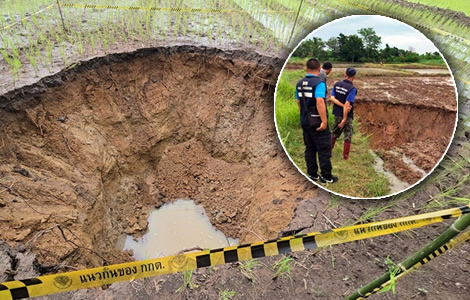
Khon Kaen province is preparing to declare part of Phu Pha Man district a disaster area after seven giant sinkholes tore through farmland, frightening villagers and triggering an urgent geological investigation.
The collapses struck Ban Wang Charoen, Village 2, in Huai Muang subdistrict on August 4. The affected fields lie about 12 kilometres from Phu Pha Man cliff and the district centre. Officials immediately moved to assess the growing danger.
Initially, inspectors identified seven sinkholes scattered across rice fields and other agricultural land. Several had already begun expanding. Others continued deepening as the ground slowly gave way.
Consequently, anxiety spread quickly through the village. Farmers feared more land could disappear beneath their feet. Authorities, however, stressed that nearby tourist attractions remain unaffected. They said the danger is confined to agricultural areas.
Provincial teams descend on village as disaster declaration nears and officials map danger zones
The provincial response intensified the following morning. At 10.30 am on Wednesday, August 5, officials gathered at the Huai Muang Subdistrict Administrative Organisation headquarters before heading to the scene. Regional Office 2 director Oruma Summat led the geological team.
She was joined by Huai Muang Subdistrict Administrative Organisation chief Khompet Khonsing, Khon Kaen MP Wisarut Puupeng, eight geologists, disaster relief personnel and local officials. Community leaders also accompanied the inspection.
Meanwhile, Khon Kaen Governor Khajornkiat Rakpanichmanee confirmed Ban Wang Charoen will be declared a disaster area. The decision followed the identification of additional high-risk locations.
In response, officials will seal off dangerous ground and restrict public access. They will also begin assistance procedures permitted under disaster relief legislation. Further inspections will continue across the village.
During the survey, geologists examined every collapse. They found each sinkhole was circular in shape. Most measured between four and five metres deep. According to Ms Oruma, each formed when surface soil collapsed into underground cavities.
Geologists confirm natural collapse as expanding sinkholes expose underground limestone cavities
She said the cavities themselves are unlikely to continue expanding. Therefore, authorities believe the holes can be temporarily filled with soil while monitoring continues.
Notably, one sinkhole had deteriorated dramatically. Officials measured it at roughly six metres by five metres. It was about three metres deep. The collapse sits inside a rice field belonging to local residents. Investigators said it had gradually widened over two days rather than collapsing suddenly. Nearby sinkholes had also grown larger during the same period.
Elsewhere, inspectors identified the most dangerous location inside a sugarcane plantation west of the village. There, persistent rainfall accelerated soil erosion around an existing collapse. Officials believe another section could fail at any moment.
Accordingly, the area has been cordoned off and entry prohibited. Water was also seeping from the bottom of one sinkhole, adding to concern about conditions beneath the surface.
According to the Department of Mineral Resources, the collapses resulted from natural geological processes. Ancient limestone beneath the village fractured millions of years ago through tectonic movement.
Over time, those fractures created underground cavities. Eventually, weakened soil above the voids collapsed. Geologists said the mechanism matched previous sinkholes recorded nearby.
Officials trace recurring sinkholes to limestone geology as surveys reveal a pattern across the district
Separately, officials confirmed the district has a long history of recurring sinkholes because of its limestone geology. Environmental conditions and land use may also contribute to the process. However, investigators have not identified every factor behind the recent increase. The geological assessment remains ongoing.
Mr Khompet said preliminary findings clearly classified the incident as a natural disaster. He said earlier surveys had already documented similar collapses across the district.
Even so, villagers told officials such events never occurred during their ancestors’ lifetimes. Instead, sinkholes have only appeared during the past decade. This year, they have emerged more frequently than before.
On another front, district chief Siwakorn Mitrat ordered an immediate local inspection after receiving reports of the collapses. He assigned senior district official Prachuap Chitkhum to coordinate the response. Officials from the Huai Muang Subdistrict Administrative Organisation joined the operation. Community leaders assisted survey teams throughout the inspection.
Farmer’s bubbling field sparks warning as geologists urge villagers to watch for fresh signs of collapse
One farmer described spotting a warning sign moments before disaster struck. Ranong Khaophuang said bubbles suddenly appeared while she transplanted rice seedlings in her four-rai field. She immediately retreated because she feared the ground would collapse beneath her.
Afterwards, she questioned whether nearby limestone quarry operations had contributed to the sinkholes. Authorities, however, said no link has been established.
As part of the investigation, geologists warned residents to watch for bubbling water or air escaping from the ground. They said both could indicate underground cavities. Either sign may precede another collapse.
Residents have therefore been urged to report suspicious ground movement immediately. Farmers should also inspect fields carefully before entering them. Officials warned them to stay away from visible cracks and surface fissures.
Importantly, geologists stressed the land is subsiding gradually rather than collapsing instantly. Nevertheless, existing sinkholes continue expanding and deepening over time.
Damage surveys begin as officials prepare compensation while monitoring expanding sinkholes
That steady movement increases the danger around affected farmland. Monitoring will continue until the ground stabilises. Survey teams will also inspect neighbouring fields for fresh cracks and additional subsidence.
In parallel, the Huai Muang Subdistrict Administrative Organisation has begun documenting agricultural damage. Officials will use the survey to calculate compensation for affected farmers.
Bangkok engineers scrambled to repair another large sinkhole in the busy Bang Kapi area of the capital
Samsen Rd sinkhole erupts in Parliament collapsing the session after People’s Party refused a debate
Eligible applicants must have been registered before the disaster occurred. Current regulations provide assistance of up to 1,500 baht per rai. Officials also referred to agricultural disaster relief at 1,340 baht per rai during planning discussions.
For now, safety cordons remain around every high-risk location. Geologists will continue monitoring the village for fresh collapses and underground movement. Provincial officials are also preparing the formal disaster area declaration while inspections continue across the affected farmland.
Join the Thai News forum, follow Thai Examiner on Facebook here
Receive all our stories as they come out on Telegram here
Follow Thai Examiner here
Further reading:
Just another accident or disaster on Saturday as Thailand’s image abroad takes a battering this week
Italian Thai boss and 16 others arrested on Thursday charged with Auditor General building deaths
Arrested man linked with Chatuchak building collapse now tells police he is a Chinese state employee
Prime Minister orders arrests over the Chatuchak Auditor General building disaster within seven days
Chinese steel firm linked to Chatuchak disaster faces DSI probes. Minister cancels investment status
Storm clouds gathering over Chinese firm at the centre of the collapsed Chatuchak building disaster
US scan shows 50-60 human beings said to be in a hallway within the collapsed Chatuchak building